
FORTIFIED HILLTOPS: CIMA MUGHERA
A hike to discover the underground defensive complexes of Punta Retello, Cima Mughera and Puria di Tignale.
Set off from the biologic oil mill in Tignale and walk uphill towards Olzano. From Piazza San Lorenzo, follow the picturesque vicolo Mure. You already are on trail 266; follow it up to the crossroads with trail 255. The latter branches off from the former near a spot with a bank, it goes through an area named La Forca and reaches Acqua Sinega. Near the spring in Acqua Sinega the path joins trail 253. Before reaching Passo d’Ere, near a bend to the left, take trail 261b. Walk past the metal bar blocking vehicle traffic to reach the mountain ridge. The tunnels dug into the ridge were part of the second defence line during the First World War. The tunnels on the rocky slopes of Cima Tignalga (trail 9) were also part of the natural defence line. When you reach the crossroads of Passo Scarpapè, take trail 261 to Passo d’Ere and then trail 253 to the alpine hut of Cima Piemp. Right before you reach the hut, on your left, you can take trail 256 to get back to La Forca. From there, you can easily reach the starting point by following trail 255 and then trail 266.
1 - CHARCOAL PRODUCTION
Charcoal production in Tignale has a centuries-old history. Especially at the end of the 18th century, as the charcoal demand grew, charcoal burners became very important. Charcoal was mainly used to burn roof tiles, to work iron, for lime production and in forges. After they had selected a working area, charcoal burners had to dig a flat dip (called “giàl”) with a diameter of 5 to 6 metres. At its centre, they drove a 3-metre-long stake, and stacked wood all around it.
In order to produce charcoal, the combustion process was essential. To adjust combustion, the stack of wood was tied together with thin dry branches and then covered with rotting leaves and soil. From the chimney at the top of the structure, charcoal burners set fire to the wood by means of a long stick covered with burning bark. This meticulous work took several days, during which charcoal burners and their families had to live in makeshift shelters.
Along the trail connecting La Forca with Acqua Sinega, there are several “giàl”, which bear witness to the charcoal production carried out till the second post-war period.
2 - PUNTA RETELLO AND CIMA MUGHERA
In the whole Puria area, especially on trail 261b, grow plenty of mugo pines. These plants usually grow in rocky environments at a height between 1300 and 1700 metres.
Cima Mughera was named after this botanical species.
You can access this area following a path dating back to the First World War. The view of nature from there is worth the hike. To reach the spot, you must walk through the military posts in the caves, which make the mountain look like an open-air museum. There you can often see beautiful wild animals, such as chamois, steinbocks and short toed eagles.
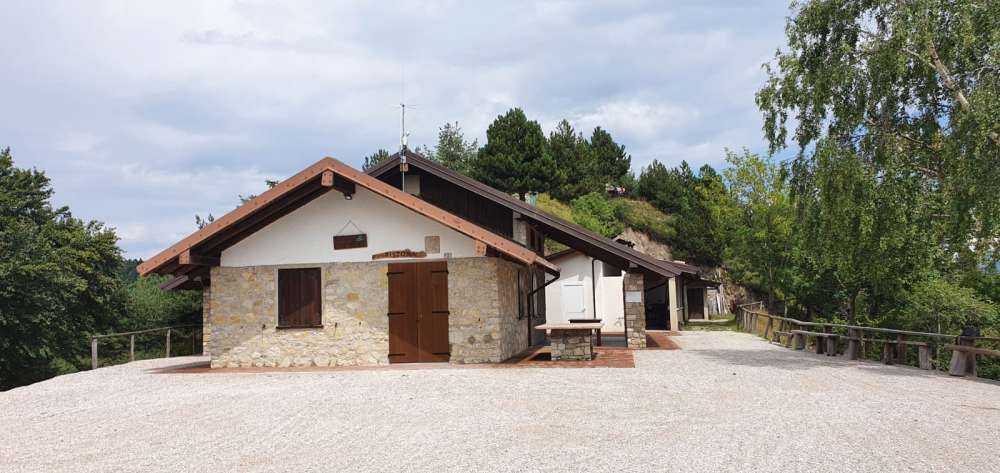
3 - THE ALPINE HUT OF CIMA PIEMP
The alpine hut of Cima Piemp was built from the Alpini Group of Tignale in the 80s. It is situated in a strategic position, in the middle of a dense network of trails, with a view of the lake and of the mountains. The Piemp hill can also be reached by car. The building was recently renovated and today it is equipped with tables and banks. Under its porch you can also have a barbecue.
TECHNICAL DETAILS


Ufficio Unico del turismo di Tignale
Via Provinciale, 1- 25080 TIGNALE (Bs)
Tel. +39 0365 73354
Information on data processing
DOWNLOAD THE NEW APP "VISIT TIGNALE"